Grants for Assessing the Benefits of Satellites (GABS)
GABS-funded research projects quantify the benefits of satellite data that inform decisions and lead to improved outcomes.
Overview
Since 1952, Resources for the Future (RFF) has been a leader in economic analysis and policy innovation for managing environmental and natural resources. RFF is developing studies about the societal value of Earth observations as part of our Consortium for the Valuation of Applications Benefits Linked to Earth Science (VALUABLES), made possible through a partnership with the National Aeronautics and Space Administration (NASA). VALUABLES is focused on advancing innovative uses of existing techniques and developing new techniques for valuing the information provided by Earth-observing satellites.
Through its Grants for Assessing the Benefits of Satellites (GABS), VALUABLES sought proposals for research to quantify the benefits of using satellite data in decisions that improve socioeconomic outcomes for people and/or the environment. In 2020, RFF announced the winners of three grants, totaling $300,000. The three winning teams were led by researchers from Moravian College, Salisbury University, and the University of Wyoming, with transdisciplinary personnel drawn from eleven more academic institutions and organizations.
The award winners conducted impact assessments that quantify the societal benefits of using Earth observations in health, ecosystem, and water quality applications. The results of their research are available in a series of working papers released by RFF.
GABS Awardees
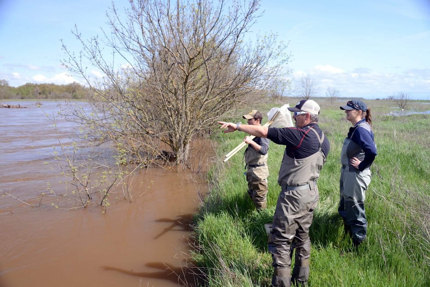
Quantifying the Benefits of Using a Satellite-Derived Early Warning System to Predict Cholera in Bangladesh
Sonia Aziz (Moravian College) led a field experiment that provided a satellite data–driven early warning system for cholera in Bangladesh through access to a cell phone app for a “treatment” community. Cholera rates and other outcome metrics were compared to those of a “control” community without the app. The project team included Emily Pakhtigian (Penn State University), Ali Akanda (University of Rhode Island), and Kevin J. Boyle (Virginia Tech). Read the full working paper.
“We expect to provide estimates of potential societal benefits of satellite data as well as necessary inputs for policymakers to design and implement effective policies to limit the incidence and spread of cholera,” said Aziz and her colleagues at the start of the project. “Providing households with satellite-aided information regarding the nature of cholera risk should improve their averting decisions.”


Estimating the Social Benefits of Satellite Imagery Used to Enforce Policy and Reduce Deforestation in the Brazilian Amazon
Jill Caviglia-Harris (Salisbury University) led a project to explore how the Brazilian Forest Code is enforced through the use of satellite data that monitors deforestation. Satellite data already are being used for management and enforcement; this project estimated how much deforestation would have happened without the satellite data and compare that to deforestation and its consequences with the satellite data. The project team included Andrew Bell (New York University), Trent Biggs (San Diego State University), Katrina Mullan and Thaís Ottoni Santiago (University of Montana), Erin Sills (North Carolina State University), and Thales West (New Zealand Forest Research Institute). Read the full working paper.
“This will be the first study to estimate the amount of avoided deforestation resulting from the use of satellite images to support the Forest Code,” said Caviglia-Harris and colleagues at the start of the project. “Our contributions will add to the limited evidence on whether and how the availability of satellite imagery has helped protect designated areas, and the even thinner literature on the benefits of monitoring deforestation to inform climate change policy and commitments.”


Valuing Satellite Data for Harmful Algal Bloom Early Warning Systems
Stephen Newbold (University of Wyoming) led the development of a model that describes how lake visitors in California adjust their recreation choices when outbreaks of harmful algal blooms are announced. This improved our current understanding of how early warning systems supported by satellite data allow recreators to divert their visits away from water bodies currently experiencing a bloom, and instead visit un-impacted sites, thereby increasing the overall enjoyment of water-based recreation activities, reducing the risks of adverse health effects, and mitigating the regional economic impacts associated with lost visitation days. The project team included Sarah Lindley and Shannon Albeke (University of Wyoming), Joshua Viers (University of California, Merced), Robert Johnston (Clark University), and George Parsons (University of Delaware). Read the full working paper.
“Predicting where and when these events will occur is an ongoing challenge, and early prediction is important because it allows steps to be taken to reduce the damage caused by harmful algal blooms,” Newbold and colleagues said at the beginning of the project. “The case study should shed light on the value of satellite-based early warning systems in other regions of the United States and beyond.”

Application Process
The GABS call for proposals has ended.
VALUABLES is no longer accepting applications for GABS. The information below serves as an archive of documents and information related to the original call for proposals.
Research Themes, Deliverables, and Outcomes
We are seeking proposals for case studies that will support and enhance the activities of the VALUABLES Consortium.
Proposals must address a decision context in which satellite data (not limited to NASA data) play a role, including applications relating to human health, air quality, water resources, ecosystem services, natural disasters, food security and agriculture, wildland fires, energy, urban development, and transportation and infrastructure. Applicants should examine the impact assessments already completed or in progress on the VALUABLES website. Preference will be given to proposals that focus on decision contexts not already addressed by these existing assessments.
Proposals must focus on evaluating the socioeconomic impacts of applications of Earth observations and quantify, in monetary terms, their value. In so doing, the proposal should clearly describe how information from satellites makes improvements to decisionmaking and the economic value of that improvement. These improvements can be in marketable outcomes or may be non-market benefits.
Estimating the societal benefits of satellite information requires defining a counterfactual case. This can be defined in two general ways: If satellite data are currently being used to make the decisions in question, the counterfactual case is how the decisions would be made if satellite data were not available (i.e., using the next best alternative data source, model, rule of thumb, etc.). If satellite data are not yet used for the chosen application, the hypothetical case where satellite data is used is the counterfactual. Our preference is for assessments of the former counterfactual case.
Requirements and Details
Outreach and Dissemination: Proposals for these competitive awards are expected to clearly identify expected contributions to scholarship. In addition, research teams will be expected to work with VALUABLES staff to integrate their research results into the consortium’s capacity-building and communications products, which may include fact sheets, blog posts, presentation at a workshop, and a webinar. Funds for communications and outreach will be made available under separate contract.
Eligibility: Proposal teams must be located in the U.S. There are no other limitations on eligibility. We will entertain pre-proposals from academicians, local, state or federal government researchers, non-profits, for profit businesses, and others. Each team must be interdisciplinary and contain a social scientist, preferably one with experience in analyses of the value of information. Upon request, RFF will provide help in finding a suitable economist.
Funding: A total of $300,000 is available to support the grants. We expect to make no more than three awards, each in the range of $100,000. In-kind donations and/or co-funding from other research grants or sources of funds will be viewed favorably by the reviewers.
Duration: The grant performance period is up to 12 months. The start date is flexible, but applicants are encouraged to target April 2020. Interim written and oral reports to RFF will be required at intervals during project execution.
Timeline
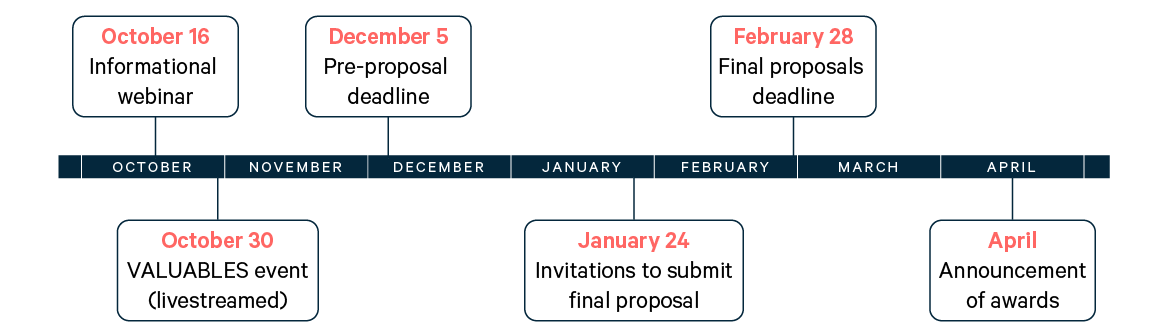
- Thursday, December 5, 2019: Pre-proposals due (by 5pm Eastern time)
- Friday, January 24, 2020: Invitation to selected applicants to submit final proposal
- Friday, February 28, 2020: Final proposals due (by 5pm Eastern time)
- Late March/early April, 2020: Award(s) announced
Application Instructions
The pre-proposal process is as follows:
To submit a pre-proposal, applicants must complete an online form and submit a brief pre-proposal limited to three pages, single-spaced, with no smaller than 11-point font and one-inch margins. (This limit does not apply to items 6., 7., and 8. below, and references). The pre-proposal, to be uploaded as one PDF document where indicated in the online form, should include:
- The title of the project
- Name, title, and professional address (including telephone number and email address) of each investigator; please also note the Principal Investigator as the main point of contact. Also note who the social scientist(s) are on the team and what roles the main researchers will play.
- A concise description of the proposed research. We expect to see clear and concise descriptions of: (a) the satellite information that generates the societal benefit to be quantified; (b) how the satellite information has improved or is expected to improve decisionmaking; (c) the socioeconomically meaningful outcomes for people and/or the environment that will change as a result of the improved decisionmaking; and (d) the empirical strategy to be used to place a value on these societal benefits.
- A concise description of the innovation the research offers
- The proposed dates for starting and completing the project
- An estimated budget including salaries, benefits, other direct costs, IDC/overhead and any matching funds (not required)
- A short budget justification, stating how the funds will be used (e.g., personnel time, travel, IDC rate, etc.); See the GABS FAQ (download below) for details about overhead rates, and
- A brief statement of prior experience of the project leader(s). Upload CVs for project leaders separately on the online form.
Informational Webinar
An applicant webinar was held on October 16, 2019; it was the only two-way interaction that the consortium will have with prospective bidders (excluding requests for help with identifying a social scientist for the project team as noted above) until the announcement of the applicants who are invited to submit full proposals. Applicants can also attend the webcast of the VALUABLES 2019 annual workshop, which will include an informational session about GABS, on October 30, 2019. Visit valuables2019-webcast.splashthat.com to register for the workshop.
Final proposals will be invited upon the recommendations of consortium staff. Final proposals should include all the information contained in the pre-proposal, more in-depth discussion of the proposed research and its anticipated intellectual and policy contribution, and a detailed budget. Please limit the proposed research discussion to five pages. Final proposals will be reviewed by a panel of experts from the academic and policy communities.
For Winners
The lead researchers on a given winning proposal will attend a kick-off meeting with VALUABLES staff in person or via conference call. At this meeting, issues with the proposal and possible revisions will be discussed and mutually agreed to prior to submission of the work plan several weeks later. This approach gives all parties a chance to fine-tune the proposal to meet the needs of VALUABLES and address the winning team’s concerns.
