Flooding in the United States 101: Causes, Trends, and Impacts
This explainer details the causes, trends, and impacts of flooding in the United States.
Introduction
Flooding occurs all across the United States and causes billions of dollars of damage to property and infrastructure every year. With climate change and population growth in flood-prone areas, both the frequency and costs of flooding are increasing. This explainer provides an overview of the state of flooding in the United States today. It describes the types of flooding, the contribution of climate change, historical trends of flood impacts and costs, the role of exposure to rising flood costs, and social vulnerability to flooding—which leads to uneven impacts of floods across people and communities.
Types of Flooding
There are three major types of flooding: fluvial, pluvial, and coastal.
Fluvial
A fluvial or river flood is a flood that occurs in and around lakes, streams, or rivers. Fluvial flooding can either be overbank flooding—when the water level rises over the edges of a river, stream, or lake—or flash flooding—where there is a high volume of water moving at a high velocity in an existing riverbed with little advance notice. Fluvial flooding is the most common type of flooding. Federal Emergency management Agency (FEMA) floodplain maps, called Special Flood Hazard Areas (SFHAs), are based on fluvial flooding. A 100-year floodplain, for example, is an area that has a 1 percent or greater probability of flooding in any given year.
While the amount, accumulation, and duration of precipitation are the main contributing factors to fluvial flooding, soil water saturation and the area’s terrain also impact the likelihood of a fluvial flood. In flatter areas, floodwaters rise more slowly but stick around for days. While in more sloping and mountainous areas, the floods tend to happen more quickly and move faster.
Pluvial
Pluvial flooding occurs when increased rainfall creates a flood independent of an existing body of water. These floods can occur in any location, even without nearby water bodies. Like fluvial flooding, pluvial floods come in two forms: surface water floods and flash floods. Surface water floods occur when a drainage system is overwhelmed. Flash floods, in this case, are just like fluvial flash floods; however, they are not contained to a river system. These flash floods are triggered by immense rainfall in a short period near low-lying terrain.
Coastal
Coastal flooding is the inundation of land along the coast by seawater. It can be caused by high tides, storm surge, and tsunamis. FEMA maps coastal SFHAs and separates them into three zones called VE, AE, and AO zones, which are based on proximity to the coast and the extent to which the lands are susceptible to waves and fast-moving water such as from storm surge.
High-tide flooding is generally defined as a coastal water level reaching or exceeding a median height of 0.5 to 0.65 meters above the long‐term average daily highest tide. The number of days with minor high tide flooding—sometimes called “nuisance” or “sunny day” flooding—in the U.S. has risen rapidly in recent years, increasing to twice 2000 levels in 2021 for an average of four days of flooding per year (See Figure 1). The numbers vary significantly by location, however; cities such as Boston, New York, and Norfolk, Virginia, average more than ten days of high-tide flooding per year.
Storm surge is the abnormal rise in seawater levels during a tropical cyclone, or hurricane, and is measured as the height of the water above the normal predicted tide. The magnitude of storm surge depends on the orientation of the coast with the track of the hurricane; the hurricane’s strength, size, and speed; and coastal and underwater topography. Whether the hurricane hits during high or low tide can matter for the resulting magnitude of flooding. In 2012, Hurricane Sandy struck the New York and New Jersey coasts at high tide, which worsened the storm’s flood impacts. While storm surge originates in the ocean, it can push deep into estuaries, bays, and rivers.
Tsunamis are giant waves caused by earthquakes or volcanic eruptions under the sea. They occur on the West Coast of the United States and are less common than hurricanes, which strike the Atlantic and Gulf coasts. Although less frequent, the forceful rapid increase in water levels in a tsunami can result in catastrophic flooding.
The Role of Climate Change
Flooding is a complex process that depends on many interrelated factors—the duration and amount of rainfall, soil types, the steepness of slopes, the amount of impermeable surfaces such as roads, and the extent of tree cover and other vegetation. This has made it difficult for scientists to formally attribute observed flooding trends to climate change. However, some key factors that lead to flooding are linked to climate change, namely extreme precipitation events, hurricane frequency and severity, and sea level rise.
Figure 1: Regional Flooding Trends in the United States

Precipitation
Climate change has led to increased average annual precipitation in some areas of the United States since the beginning of the twentieth century, namely the Northeast, Midwest, and Great Plains, and a decrease in others, particularly the Southwest. Extreme precipitation events—typically defined as a day with precipitation in the top one percent of all days with precipitation—have increased in both intensity and frequency across most parts of the country. Nine out of the top 10 years for single-day extreme precipitation events have occurred since 1996, and the percent of the US experiencing extreme precipitation is increasing by half a percentage point every decade. Scientists expect climate change to increase the frequency and intensity of heavy precipitation events over the remainder of the twenty-first century. These events lead to more flash and fluvial floods (Figure 1).
Hurricanes
The number of hurricanes has increased since the turn of the twentieth century and especially since the 1970s. Scientists have attributed some of this increase to climate change, and models suggest that a warmer climate will lead to further increases in the most intense storms over the rest of the twenty-first century. More intense storms—i.e., larger storms with greater wind speeds—have a greater potential for storm surge flooding, though many other factors also come into play.
Sea Level Rise
Global average sea levels have risen by 7–8 inches since 1900, and the rate of increase has accelerated since 1993. Along the US coast, the increases are greater—roughly 11 inches since 1900. The problem is expected to worsen in the future. In the United States, sea levels are projected to rise 10-12 inches, on average, in the next 30 years. Sea level rise varies significantly by location. The largest relative increases in the United States in the future are expected in the Northeast and the western Gulf of Mexico.
Higher sea levels amplify the effects of high tides and storm surge, even without any increase in storm frequency and intensity. As mentioned above, the occurrence of high-tide, or nuisance, floods is expected to rise from an average of approximately 4 per year today to more than 10 by 2050 due to sea level rise (Figure 1). Essentially, the coastal water levels that today we view as floods are likely to become a new high-tide normal in the coming decades. Additionally, a median eightfold increase is expected by 2050 in the number of floods that exceed the 100-year flood event. In other words, what is a 100-year flood today, i.e., a flood with an annual 1 percent chance of occurrence, will occur eight times as often in the future because of sea level rise. Storm surge flooding that occurs during a hurricane, and the wave action that often accompanies it, is also expected to worsen with sea level rise.
Flood Impacts and Costs
Different types of floods cause different damages. For example, while precipitation is the primary driver of pluvial floods, the impact of pluvial floods varies by type and location. Surface water floods are usually less than one meter deep, so they are not especially dangerous. However, the standing water generated by surface water floods can lead to damage to infrastructure and buildings and disrupt daily activities. Pluvial flash floods, on the other hand, are dangerous. The velocity of the floodwaters whisks people and debris away at hazardous speeds and can lead to landslides. Hurricanes can have devastating impacts from storm surge, heavy rainfall, wave action, and rip currents.
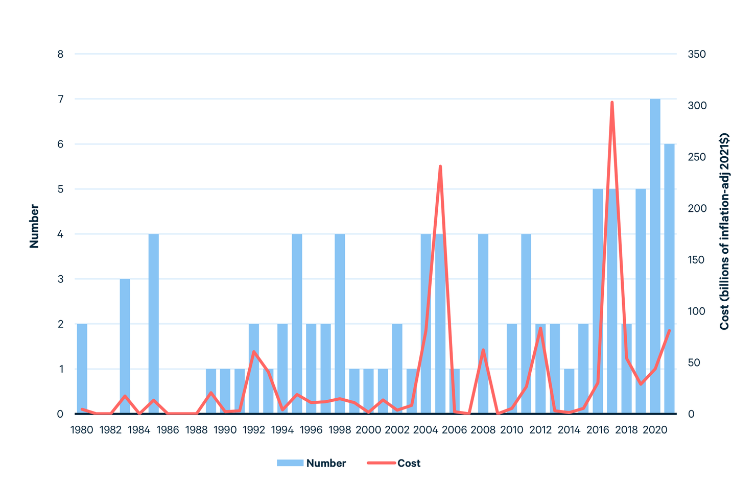
The costs of flooding and extreme weather events have risen in the United States (and worldwide) over the last 40 years. Figure 2 shows the number of flood and hurricane disasters in the United States in which the costs have been at least $1 billion (in inflation-adjusted terms) since 1980, along with the total costs for each year. Billion-dollar disasters account for approximately 80% of all disaster costs in a year. NOAA categorizes disasters into one of the following: flooding, severe storm, tropical cyclone (i.e., hurricane), winter storm, freeze, drought, and wildfire. The costs include damage to properties and infrastructure, agricultural losses, business interruption expenses, and storm cleanup.
Figure 2. Number and Cost of Flood and Hurricane Events
Flood Risk
Flood risk—i.e., the likelihood of damages and costs from a flood event—is a function of flood hazard and exposure.
Hazard refers to the physical factors that make an area susceptible to flooding, such as elevation, rainfall patterns, including the frequency of extreme precipitation events, regional sea level rise, rivers, and snowmelt. Exposure refers to the number of people and value of properties that are located in high flood-risk areas.
While climate change is increasing flood hazard in many locations, population growth in coastal areas and historic floodplains is increasing exposure. As more people move to cities and urban areas, many of them in coastal counties, there is a growing demand for housing, commercial properties, and infrastructure. With many cities’ growth constrained against the coast or shorelines, previously undeveloped, flood-prone areas may be one of the few affordable options for developers, making building in these areas attractive despite the risks. Development that is allowed by rights, based on historical zoning and other factors, can limit the extent to which cities can prevent development in risky areas. The city of Norfolk, Virginia, provides a stark example: https://wetlandswatch.org/directors-blog/2022/1/15/when-youre-in-a-hole-stop-digging. This, combined with the loss of wetlands and other natural infrastructure that protects landscapes from floods, has increased the likelihood of flooding and increased exposure to flood hazards. One recent study estimates that 7.3 million single- and multifamily homes along the Gulf and Atlantic Coasts are at risk of storm surge flood damage. The estimated cost of reconstruction for these properties is nearly $1.8 trillion.
Several factors may explain why people continue to live in high flood risk areas. Homebuyers may not fully understand the extent of flood hazards they face in particular areas. Although FEMA has mapped SFHAs for decades and requires flood insurance for properties in SFHAs that have federally-backed mortgages, the maps are a simplified way of conveying information about risks and may lead people to assume that risks fall to zero after crossing the SFHA line. FEMA is now working on more nuanced ways of communicating risk to developers and homebuyers in flood zones throughout the country. Through the development of updated flood maps and a new pricing mechanism for flood insurance called Risk Rating 2.0, information regarding flood plains could better reflect the risk of living in certain areas. An independent organization, First Street Foundation, has also recently created flood risk factors for individual properties across the United States and made the information available in partnership with home listing services, such as Realtor.com and Redfin.
Comprehensive policies are needed to reduce exposure in flood zones—including building codes and land use regulations, accurate flood risk maps and flood disclosure requirements, zoning laws that limit development in the most high-risk areas, and government incentives to build in low-risk areas
Vulnerability of High Flood-Risk Communities
Many of the physical components of vulnerability were touched on in earlier sections. Rising precipitation, sea level, and storm intensity all contribute to increased vulnerability to high flood-risk communities. Additionally, the quality of homes and condition of a community’s infrastructure affects its vulnerability. For example, aging infrastructure, constructed decades ago, may be less resistant to flooding.
People are increasingly recognizing that social vulnerability can drive the severity of impacts of flood events and the ability of communities to recover. Social vulnerability is determined by a set of socioeconomic factors that exacerbate the harm caused by flooding—such as low incomes, high rates of poverty, low education, underlying health conditions, English-language challenges, and a range of other factors.
Economic status is one of the key determinants of social vulnerability. Low-income households are more likely to live in flood-prone areas due to the affordability of housing. These households may lack the financial resources to prepare for and recover from floods. They may also be unable to evacuate to safer areas during flood events due to financial constraints, putting them at greater risk of injury or death. Many studies have shown that low-income households are less likely to have flood insurance, which provides the quickest and most complete means of recovery after a flood event.
These same communities often lack the funds for substantial infrastructure investments. As a result, old drainage systems, worn roads, and inadequate flood protection measures can exacerbate the impacts of floods, making it difficult for residents to access basic services and evacuate during flood events. In addition, inadequate infrastructure can result in increased flood damages to homes and properties, creating a positive feedback loop resulting in a larger decline in household wealth and community economic activity.
Demographic factors, such as age, health status, and race, can also affect social vulnerability to floods. Older adults and those with chronic health conditions may have difficulty evacuating during floods or accessing necessary medical care. Children, who are often more vulnerable to environmental hazards, may also be disproportionately affected by floods. Racial minorities may be more likely to live in low-income areas that are prone to flooding due to historical redlining practices and discrimination. Additionally, education and language can impose barriers to communicating flood risks and emergency response.
Careful policies are needed to reduce the impacts of flooding, factoring in trends from climate change and community risk. These policies will be covered in an upcoming explainer.