Recreation and Resilience: When Parks Do Double Duty
This report describes the double-duty performed by stormwater parks in three cities in the United States: Atlanta, Houston, and Virginia Beach.
Abstract
Extreme precipitation events are increasing in many areas of the United States, leading to a growing number of damaging flood events. Nature-based solutions (NBS), which use natural features or processes to absorb and redirect floodwaters away from developed areas, are often seen as environmentally friendly alternatives to hard infrastructure for flood protection, such as levees and seawalls. Some NBS are small-scale, but stormwater parks are often several acres in size and provide important community co-benefits in the form of outdoor recreation. In this report, we describe the double-duty performed by stormwater parks in three cities in the United States, Atlanta, Houston, and Virginia Beach. We explain how the cities overcame five major challenges to successfully design, construct, and finance the parks. We then discuss the special challenges that small towns face in developing solutions to flooding problems and describe the situation in two Maryland towns where valuable community parks are flooding hot spots.
1. Introduction
Weather extremes are increasing in many areas of the United States, leading to a growing number of catastrophic flood events. In coastal communities, the problems are particularly serious as sea level rise poses an added threat, exacerbating both routine high-tide flooding and flooding from hurricane storm surges (Holmes and Walls 2024; Walls et al. 2023).
Nature-based solutions (NBS) have emerged in recent years as a way to address these flooding challenges (DeAngeli et al. 2024). NBS use natural features or processes to absorb and redirect floodwaters away from developed areas and are often seen as an environmentally friendly alternative to hard infrastructure such as dams, levees, seawalls, pipes, and tunnels. In urban settings, where NBS are frequently referred to as green infrastructure, the features can include rain gardens, bioswales, urban forests, riparian buffers, constructed wetlands, and stormwater parks. In many settings, these green approaches lead to improvements in surface water quality that are equally as important as flood protection.
While some NBS, such as bioswales and rain gardens, are comparatively small in scale, stormwater parks can be several acres in size and provide important community co-benefits in the form of outdoor recreation. Stormwater parks are designed to flood; by incorporating ponds, wetlands, and vegetation that store and absorb water, they protect surrounding areas and homes from flood damage (FEMA 2021; City Parks Alliance 2024). When they are not flooded, these natural features serve as scenic green spaces and water features for local communities. Many stormwater parks also include developed recreation options, such as sports facilities and playgrounds. The double duty that stormwater parks perform—providing both flood protection and access to recreation—sets them apart from many other types of NBS.
Interest in stormwater parks is growing, but designing, constructing, and maintaining them can be challenging, and communities face several hurdles when trying to get it right. In this study, we highlight three cities that have successfully created, or are in the process of creating, new stormwater parks. We describe their experiences and draw lessons learned for other communities, identifying five key factors for success: (a) adequate funding; (b) a strong partnership across local government agencies; (c) an integrated city- or region-wide flood mitigation/climate resilience strategy; (d) attention to the specialized design, construction, and maintenance needs of stormwater parks; and (e) the creation of significant recreation and economic development benefits. We end with a discussion of smaller communities where flood risks also loom large but resources are more limited. Using two communities in Maryland as examples, we describe the specific challenges these communities face.
The growing impacts of climate change are forcing communities to take steps to build resilience—to move from acknowledging problems and developing plans to implementing projects on the ground. At the same time, community leaders want their citizens to have high quality of life, and parks and open space are an important part of the quality-of-life equation (Carlino and Saiz 2019; Akhundjanov and Jakus forthcoming). Parks can also be a key driver of economic development, affecting businesses’ and workers’ decisions about location and driving up wages, property values, and local tax revenues (Szabó and Ujhelyi 2024; Mueller et al. 2021; Anderson and West 2006; TPL and HR&A 2024). Communities benefit in multiple ways when parks are reimagined as integral aspects of resilience strategies.
2. Atlanta’s Rodney Cook Sr. Park
Multiple watersheds come together in the city of Atlanta, creating conditions that make the city susceptible to flooding. In 2002, Tropical Storm Hanna caused heavy rainfall that led to a major flood event in Vine City, a neighborhood west of downtown Atlanta, destroying hundreds of homes. The catastrophic event catalyzed city leaders to find solutions to their flood problems, including buying out 60 properties on a 16-acre parcel of land. Working in partnership with the Trust for Public Land, the city ultimately turned the site into Rodney Cook Sr. Park. Some of the information reported in this section was gathered from a helpful conversation between the authors and Gaylan Williams, Deputy Commissioner of Park Planning and Design for the City of Atlanta, and Tamara Graham, Environmental Program Manager for the City of Atlanta Department of Watershed Management (Williams and Graham 2025).
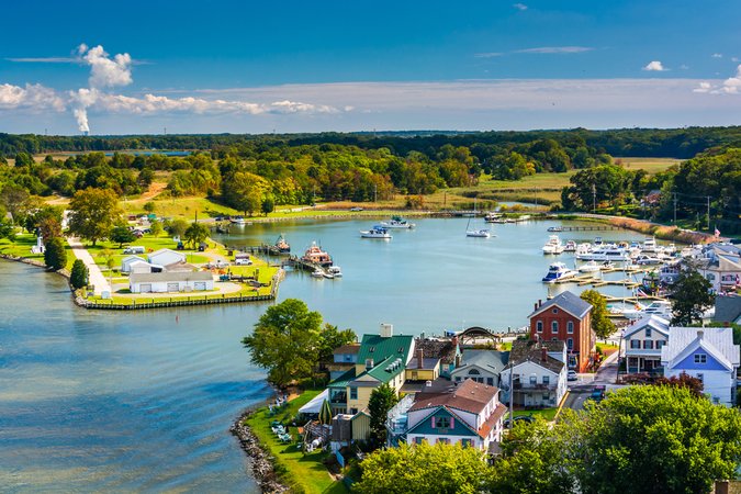
The park, completed in 2021 at a final cost of $45 million, features walking trails, playgrounds, basketball courts, picnic areas, a two-acre pond, and green spaces. The infrastructure of the park includes a state-of-the-art stormwater catchment and filtration system, designed to retain polluted water flowing from downtown Atlanta’s impervious surfaces. The on-site retention pond can store up to 10 million gallons of water during storms and allows the city to treat contaminants before releasing the water back into the city’s system (TPL n.d.). All of the materials used in the park, including play surfaces, fencing, and walkways, are designed to withstand and recover from flooding. The Atlanta Parks Department and Department of Watershed Management collaborated to incorporate both stormwater management practices and recreational facilities into the park’s design.
Funding for the project came from a diverse set of sources, including a US Environmental Protection Agency (EPA) grant program for nonpoint-source pollution, a city-wide environmental impact bond for green infrastructure, and philanthropic foundations (City of Atlanta Department of Watershed Management n.d.; Montgomery 2025). The park is one component of a larger green infrastructure effort in Atlanta’s watersheds to control flooding and water pollution, including the Greensferry Stream and Floodplain Restoration Project See https://expertcenter.res.us/blog/the-greensferry-project-revitalizing-atlantas-proctor-creek-watershed. west of Cook Park, which is designed to restore the Proctor Creek Watershed, also funded by the environmental impact bond. See https://atlantawatershed.org/environmental-impact-bond/.
Cook Park is located in a neighborhood that was once vibrant and middle class but had become distressed by the early 2000s. See https://www.hdrinc.com/portfolio/rodney-cook-sr-park-historic-vine-city. The park is a highly valued recreational amenity in addition to providing flood protection, and city leaders view it as an economic engine for the neighborhood.
Figure 1. Aerial Photo of Rodney Cook Sr. Park, Atlanta
Source: Dudley 2021.
3. Houston’s Inwood Detention Basin
The Houston area Some of the information reported in this section was gathered from a helpful conversation between the authors and Melissa Meyer, Director of Partnerships and Programs, Harris County Flood Control District, and Trent Rondot, Conservation and Maintenance Director, Houston Parks Board (Meyer and Rondot 2025). faces high flood risk due to its flat topography, sandy soils, intense rainfalls, and sprawling development that has created extensive areas of impervious surfaces. After Hurricane Harvey hit in 2017 and caused unprecedented damage to the greater Houston area, Harris County began to prioritize flood control efforts and develop adaptation strategies (Harris County Flood Control District 2025). About five years earlier, the nonprofit Houston Parks Board had begun its Bayou Greenways project, which aims to construct 150 miles of trails and parks, connecting Houston’s bayous and creating natural amenities for residents. See https://houstonparksboard.org/initiatives/bayou-greenways/. The Inwood Detention Basin, a former 226-acre golf course in the middle of the bayous that was long abandoned and chronically flooded, was identified as a location that could serve as both a Harris County flood control project and a Houston Parks Board bayou connection project. The defunct golf course’s old fairways were envisioned as locations for flood retention and natural areas that could be used for passive recreation.
The Inwood Detention Basin was not the first collaboration between Houston Parks Board and Harris County Flood Control District; they began working together in 2004 to improve Brays Bayou. Harris County Flood Control District purchased land for projects, but when they only needed a portion of the property to achieve their flood control goals, Houston Parks Board would purchase the remainder, convert it to green space for recreation, and provide the necessary park maintenance. The ongoing partnership between the two organizations allows for more opportunities for projects from pooled funding and a sharing of maintenance equipment and costs. The Harris County Flood Control District also views the partnership as helping to improve their own relationship with residents, as they can engage with residents about parks and open space rather than about the often frustrating problems caused by flooding.
The cost of the Inwood project is estimated at $80 million, See https://www.engagehouston.org/inwood-forest-regional-detention. with funding coming from a variety of sources, including a Federal Emergency Management Agency (FEMA) grant received in the wake of Hurricane Harvey, a city-wide bond, and Houston Parks Board philanthropic partners.
While built infrastructure for sports and play are highlights of Cook Park in Atlanta, the Inwood planners focused strongly on green space. Nearby residents—10,000 people live within a 10-minute walk of the park—were initially hesitant about the project due to concerns about the detention basin, but the basin proved scenic and the 12 miles of trails have widespread support from residents. Moreover, the benefits are not just for nearby residents, as the trails are part of a walking and biking system used by residents across Harris County. As for flood benefits, engineers estimate that the park’s flood detention capacity will effectively remove 264 homes from the 100-year floodplain (Asakura Robinson 2020).
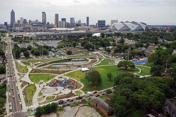
Figure 2. White Oak Bayou, Houston, Texas
Note: The image captures one of the sites developed as a part of the Bayou Greenways project.
Source: Jonnu Singleton/Houston Parks Board.
4. Virginia Beach’s Bow Creek Stormwater Park
Like Atlanta and Houston, Virginia Beach experienced damaging flooding from a storm event—Hurricane Matthew in 2016. The hurricane produced record-setting rainfall of more than a foot in 12 hours and damaged several thousand homes, prompting concern from Virginia Beach leaders and residents about the ability of the city’s infrastructure to handle high amounts of precipitation from storms in addition to inundation from sea level rise (City of Virginia Beach Department of Public Works 2020). The city is low lying, with scattered “bowls” from which floodwaters drain slowly and areas near the Back Bay that have lost wetlands, which originally were able to attenuate flooding. To address the complex problems it faces, the city developed an adaptation strategy, including NBS, to tackle existing and future flooding issues (City of Virginia Beach 2020).
A key component of the plan was conversion of the 100-acre, publicly owned Bow Creek golf course into a stormwater park. Some of the information reported in this section was gathered from a helpful conversation between the authors and Michael Kirschman, City of Virginia Beach Parks and Recreation Director (Kirschman 2025). In contrast to the Houston case, the golf course in Virginia Beach was still operational. In spite of this, the Parks and Recreation and Public Works Departments—the city partner agencies working to implement the project—faced little pushback from the community. Residents had experienced the damage from Hurricane Michael (and a subsequent storm) and were calling for solutions to flooding problems. In addition, the creation of several new recreational amenities, including paved trails, scenic overlooks, a community center, a kayak launch, and pickleball courts compensated for the loss of the golf course.
Revenues from the city’s stormwater fee and a $567 million bond issued in 2021 are covering most of the cost of the project, and a total of $83.6 million has been appropriated so far for the fiscal year 2023 (FY23) through FY28 period. See https://s3.us-east-1.amazonaws.com/virginia-beach-departments-docs/budget/Budget/Adopted/Capital-Improvement-Programs-2023-2028.pdf. The city is also investing in trained natural resources staff to ensure upkeep of the significant investment made in new native plants. The total worth of the native plants used in this project is $8 million. As of fall 2025, the first section of the park was 80 percent complete and slated to open in spring 2026, three years ahead of the original schedule. The finished park will be able to store up to 400 acre-feet of water, protecting surrounding low- to middle-income neighborhoods during heavy precipitation events.
Figure 3. Virginia Beach’s Bow Creek Stormwater Park
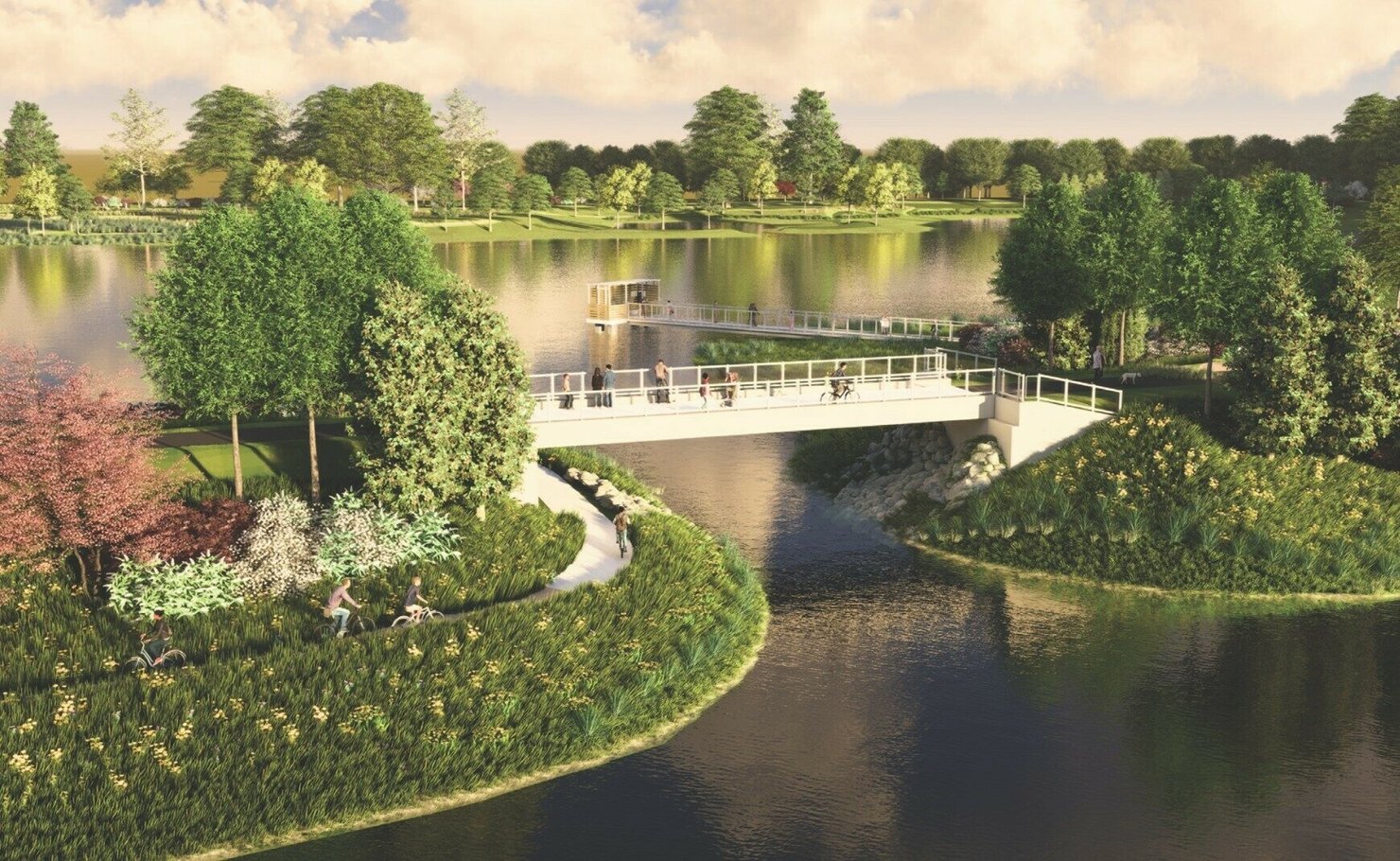
Note: Conceptual art of Bow Creek Stormwater Park in Virginia Beach.
Source: City of Virginia Beach 2025.
5. Overcoming Challenges: Five Factors for Success in Atlanta, Houston, and Virginia Beach
Carrying out a complex project such as a stormwater park, from concept to design to construction and operation, and ensuring it is an integrated component of a larger flood resilience network, is no easy task. We identify five main challenges that Atlanta, Houston, and Virginia Beach faced and overcame when implementing their stormwater parks:
- securing funding
- facilitating collaboration between often siloed local government departments (and in the case of Houston, a key nonprofit partner)
- aligning projects under a city- or watershed-wide strategy
- employing the right experts for park design and maintenance
- ensuring the community reaps recreation and economic development benefits.
5.1. Securing Funding
It is hard to overstate the importance of money in bringing these projects to fruition. The parks in Atlanta, Houston, and Virginia Beach cost between $45 million and $84 million. Securing funding for these kinds of large capital projects can be daunting.
In each of the three cities, leaders pulled together funding from a variety of sources. All three issued voter-supported bonds to finance the projects. In Virginia Beach, the city’s stormwater utility fee generated important revenues. Houston and Atlanta both received federal grants—Houston a FEMA disaster assistance award after Hurricane Harvey and Atlanta a grant from the EPA Clean Water Act 319 program, which funds solutions to nonpoint-source pollution problems. See https://www.epa.gov/nps/cwa-ss319-grant-current-guidance. Thus, in both cases, the federal assistance was reactive—that is, it came in response to an environmental pollution problem or disaster that the city experienced.
Sizable philanthropic donations were obtained in Atlanta and Houston, especially for the recreational components of the projects. In Atlanta, the Trust for Public Land played a key role in envisioning the park and bringing it across the finish line, including raising an estimated $12.7 million from foundations, corporations, and individual supporters. See https://www.investatlanta.com/impact-insights/atl-officials-break-ground-on-vine-citys-rodney-cook-sr-park. The Houston Parks Board provided funds for the trails, landscaping, and other recreational features of the Houston park. See https://houstonparksboard.org/inwood-recreation-project/. Houston has a unique approach for maintenance costs, which can be substantial: the city agrees to take the tax revenues estimated from the property value increases in an economic impact area around the Bayou Greenways and put it toward a maintenance fund that goes to the Houston Parks Board, which handles the maintenance for the Greenways, including Inwood. Texas Local Government Code Chapter 380 allows municipalities to use local revenues to award grants (or loans) to nonprofit organizations for economic development purposes. For more information, see https://comptroller.texas.gov/economy/development/grants/ch380-381/. The idea of using expected increases in property values to pay for infrastructure is often referred to as tax-increment financing, or TIF (Greenbaum and Landers 2014).
5.2. Facilitating Interdepartmental Collaboration
The collaboration between parks agencies and stormwater utilities/flood control districts is extremely important to the success of stormwater park projects. Local government departments are often siloed, focusing on the priorities and mandates they face as established in local municipal codes and regulations. In these three cities, however, the agencies involved in the park projects ended up in close working relationships with each other, allowing the parks to provide both recreation and flood reduction benefits, often at lower overall costs.
In working together, representatives from the three cities report numerous benefits from working across departments. In Atlanta, the Department of Parks and Recreation and Department of Watershed Management have pooled resources to bring larger projects to fruition than either could have done on its own. The Virginia Beach Parks and Recreation Department coordinates with the Department of Public Works around key land parcels in the city, sometimes donating some of its park land for stormwater management purposes in exchange for Department of Public Works funding for trails and other recreational amenities. In Houston, the Houston Parks Board and Harris County Flood Control District share equipment and staff for park maintenance across the Bayou Greenways. For parks to pull off the double duty of providing flood resilience and recreational amenities, bringing together the expertise of the two agencies is critical.
5.3. Aligning Projects under a City- or Watershed-Wide Strategy
A single park is not the solution to a city’s flooding problems, but it can be one component of an integrated approach. A common thread among the three stormwater parks described above is that they have been envisioned as part of a broader flood control or climate resilience strategy.
Inwood Detention Basin is part of Houston’s Bayou Greenways project, Cook Park part of Atlanta’s floodplain management plan across watersheds, and Bow Creek Park part of Virginia Beach’s comprehensive program for addressing sea level rise and flooding (known as “Sea Level Wise”). Having the park as part of an integrated region-wide effort ensures that it provides the “as-advertised” flood protection benefits to the community.
5.4. Employing the Right Experts for Design and Maintenance
To meet the combined needs of retention/detention infrastructure and recreational facilities, a city must involve design professionals to carefully plan for the stormwater park’s dual purpose as well as specialized maintenance crews to ensure the park functions properly for its full lifespan. For all three cities, the partners in charge of the project involved external design firms experienced in stormwater parks during initial planning stages. In all three cities, since the implementation of the project the stormwater utility or flood control agency has generally managed the detention basins and other flood control infrastructure while the parks agency maintains trails, vegetation, and other park features. Virginia Beach has natural resources staff that are trained to care for native plants, a common feature of many green infrastructure solutions.
5.5. Ensuring Community Recreation and Economic Development Benefits
A large body of literature has shown that access to outdoor recreation is highly valuable, and the contribution of outdoor recreation to the US economy substantial. In a comprehensive review of the economics literature, Rosenberger (2018) finds that the average value of one recreation activity-day in the United States is approximately $74. For 17 activities that are more common in urban park settings—i.e., omitting activities such as hunting, fishing, and camping—the estimate is $45 per activity-day. Using Rosenberger’s estimate of the number of activity-days for each recreation activity and scaling to the US population, this suggests a total value of urban park recreation in the United States of approximately $2.4 billion per year.
Several studies have analyzed the benefit of urban parks as capitalized in home prices, with results generally showing that closer proximity to parks, especially nature-focused parks, increases home prices and that the proximity value is higher in higher-density urban locations (McConnell and Walls 2005; Koetse 2011). Parks and recreation have also been shown to have economic development benefits. A 2024 study by the Trust for Public Land and HR&A Advisors, a real estate and economic development consulting firm, documents the positive correlation between park investments and business and job growth in five cities (TPL and HR&A 2024). Nationally, the US Bureau of Economic Analysis estimates that outdoor recreation contributed $640 billion to US GDP in 2023 (BEA 2024), approximately 2.3 percent of total GDP and more than many other industries, including agriculture and oil, gas, and mining.
Having the park simultaneously serve as recreational asset and flood control infrastructure can also open up multiple funding options. Some grant programs at the state level, for example, are only available for projects that provide recreation benefits; others, including federal grants, are resilience or disaster recovery focused. Stormwater parks open the door to both these funding streams.
6. Can Parks Perform Double Duty in Small Towns?
Growing problems with flooding and sea level rise are not limited to big cities. Many small towns face serious impacts from flooding as well. Yet these communities face their own set of special challenges. In this section, we enumerate some of those challenges and describe the situation in two towns in Maryland that face growing tidal flooding problems.
6.1. Financial Resources
The first challenge that small towns face is the most obvious one, a much smaller local tax base and limited discretionary financial resources available to put toward flooding infrastructure and parks. On average, local governments allocate the largest share of their annual spending to schools—approximately 40 percent of spending at the local level was on K-12 education in 2024 (Urban Institute n.d.), but the percentage is typically much higher for small towns and rural areas, leaving less available for other things. According to US Census data, spending on parks and recreation accounts for only 1–2 percent of total state and local government spending, and utilities and natural resources expenditures, two other Census categories that could include flood control and stormwater management (among several other things), account for approximately 7 percent of total spending. Data on state and local government spending is available from the US Census at https://www.census.gov/data/datasets/2023/econ/local/public-use-datasets.html. Urban Institute (n.d.) also provides some statistics for 2023. It is difficult to find funding for resilience in local budgets that are often already stretched thin. In settings where serious problems will occur several years in the future and current problems are not dire, local officials are unlikely to prioritize spending on resilience.
6.2. Staffing
Small towns also face local government staffing limitations. They usually have small numbers of employees who are often responsible for multiple functions. Taking time away from these day-to-day responsibilities to fully understand local flooding problems, especially under future climate conditions, and identify feasible and cost-effective solutions is often asking too much. Even when they can take this on, there is the added time necessary to identify external funding sources for the proposed solutions and complete lengthy, technical grant applications. Small towns also do not usually have regular nonprofit partners in the way that large cities do. As we described above, these partners have been crucial to success for city stormwater parks, bringing both ideas for solutions and connections to philanthropic funding.
6.3. Watershed-Wide Resilience Strategy
A watershed or regional resilience strategy is important for fully addressing flooding problems; as we described above, an individual stormwater park is usually one component of a broader strategy. But small towns can often be left out of these broader plans. For one thing, attention at the county or regional level tends to be directed toward more heavily populated areas. And interjurisdictional hurdles often arise. When a park in a small town is municipally owned, for example, it is often ignored in a broader county-wide strategy, where the focus is on facilities owned and operated by the county. Similarly, county public works departments will address county-owned flood control and stormwater infrastructure while leaving the small municipalities on their own.
6.4. Case Studies: Flooding and Sea Level Rise in Maryland Eastern Shore Communities
Maryland’s coastal areas, including regions around the Chesapeake Bay, face significant risks from sea level rise. Tidal gauges have measured increases of approximately 0.2 inches per year between 1975 and 2020 (Boesch et al. 2023), roughly double the average rise for the United States as a whole (Sweet et al. 2022). By 2050, the state is projected to experience an additional 18 inches of sea level rise, even under conservative estimates of future carbon dioxide emissions (Boesch et al. 2023).
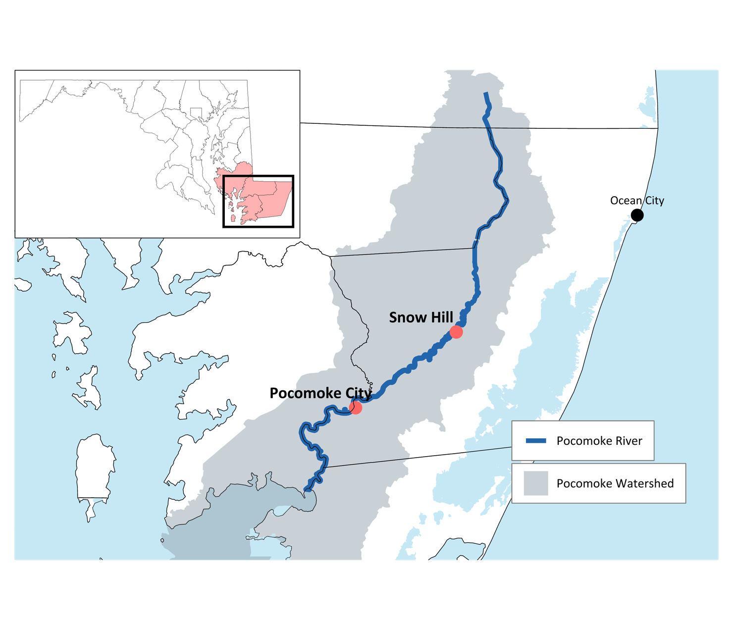
Two municipalities on Maryland’s Eastern Shore, Snow Hill and Pocomoke City, highlight some of the flooding challenges in the region and how they intersect with the provision of parks and recreation. The two towns lie along the Pocomoke River, a tidal river that runs 66 miles from southern Delaware south to the Chesapeake Bay, and each has a popular community park that regularly floods (see Figure 4).
Figure 4. Map of Pocomoke River, Snow Hill, and Pocomoke City, Maryland
Snow Hill has Byrd Park, a 17-acre park with boat ramps, a fishing pier, kayak launch, basketball courts, a playground, and picnic pavilion. The park has large grassy areas, which are often used for festivals and other events. The park routinely floods during storm events, with standing water throughout the park remaining for several days. The most seriously affected areas often have six inches or more of ponding for a week or longer (Davis, Bowen & Friedel 2022). In Pocomoke City, the nine-acre Cypress Park has heavily used pickleball courts, a pavilion, playground, picnic area, and a 1.5-mile trail along the river that includes a floating boardwalk. The park is a flooding hot spot in the city and often has standing water during storms and high tides. Recent flood modeling shows that over the 10-year period 2015–2024, at least two areas of the park were inaccessible an average of 62 days per year. The park was fully inaccessible—meaning all parts were flooded—an average of 13 days per year. These numbers are projected to rise dramatically in the future with climate change. These estimates are from flood modeling by George Mason University researchers in a current joint project with the authors and experts at The Nature Conservancy and Maryland Department of Natural Resources (DNR). See https://storymaps.arcgis.com/stories/056e494106304699803ea7811407474e. Additional details available from the authors upon request.
City leaders and residents of Snow Hill and Pocomoke City understand the problems they face, and both cities have engaged engineering firms to analyze potential solutions. Davis, Bowen & Friedel (2022) offered five options for Byrd Park in Snow Hill, one of which included construction of bioswales and vegetative buffers but not a full redesign of the park. The firm presented estimates of costs but not flood reduction benefits for the five options. Two engineering studies were completed for Pocomoke City; both provided flood modeling and cost estimates for an option that included converting a small part of Cypress Park to wetlands and elevating some areas of the park—again, not a full redesign of the park (Michael Baker International 2024; Rauch Inc. 2024). The studies found that the flood reduction benefits of this approach were minimal. Moreover, elevating the park is costly: $1.3 million, according to Rauch Inc. (2024). Elevation was also an option considered for Byrd Park and the cost estimate was $2.7 million (Davis, Bowen & Friedel 2022).
Pocomoke City and Snow Hill face many of the challenges that we described above:
- Small city budgets. Total municipal operating expenditures in the FY26 budget for Pocomoke City are $7.6 million; expenditures for Snow Hill for FY25 were $3.7 million. Budgets and financial statements available at https://www.cityofpocomoke.com/sites/default/files/documents/FY2026Budget.pdf and https://www.snowhillmd.gov/media/1831. Pocomoke City is larger; recent population estimates for the two towns are 4,426 (Pocomoke) and 2,243 (Snow Hill).
- Limited workforces. Both towns have very small local government staffs. Park operations and maintenance are part of departments that handle water and sewer services, solid waste and recycling collection, general street maintenance, and related activities.
- Lack of integrated resilience plan. Both municipalities are located in Worcester County, which published a hazard mitigation and resilience plan in 2020 (Worcester County 2020). While the plan acknowledges the flooding that occurs when storms cause the Pocomoke River to overflow its banks and the importance of wetlands in the watershed to mitigate the problem, it does not recommend any solutions. It also does not mention the specific problems in Byrd Park and Cypress Park. Worcester is Maryland’s only oceanfront county, and the majority of its population and economic activity is near the ocean, in and around Ocean City and Berlin.
Both Snow Hill and Pocomoke City are economically disadvantaged. Median household incomes and property values are lower than, and poverty rates higher than, those for the state as a whole (Table 1). Over the 20-year period between 2000 and 2020, Snow Hill experienced population decline and Pocomoke City had significantly slower growth than Maryland as a whole. Pocomoke City’s downtown area, which is walkable to Cypress Park, has several vacant buildings. Revitalization and economic development are a major focus for the town.
Table 1. Selected Socioeconomic Characteristics of Pocomoke City, Snow Hill, and the State of Maryland
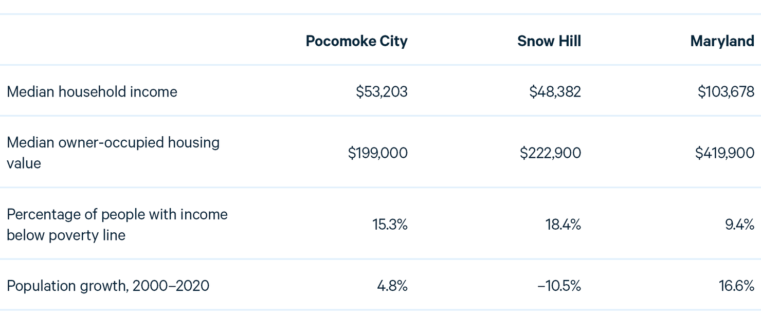
Source: US Census American Community Survey, 2020–2024, for income, housing value, and poverty line; US Census for 2000 and 2020 population.
Working in Pocomoke City and Snow Hill’s favor is Maryland’s Program Open Space, a park funding program within the state Department of Natural Resources. See https://dnr.maryland.gov/land/pages/programopenspace/home.aspx. Program Open Space operates a competitive grant program, the Community Parks and Playgrounds Program, specifically for municipality investments in land acquisition and park infrastructure development. Another part of Program Open Space provides grants to counties using a formula based on population and other factors. Worcester County uses that money outside of municipalities and closer to the main population centers in the county, so Pocomoke and Snow Hill do not directly benefit from it. The Community Parks and Playgrounds Program prioritizes its spending, in part, based on whether communities are “overburdened and underserved,” a factor determined by various socioeconomic characteristics and which applies to both Pocomoke City and Snow Hill. In addition, a new program also under the Program Open Space umbrella, Green Space Equity, was established by the state legislature in 2023. It focuses on projects to preserve, create, and improve public green space in overburdened and underserved communities.
Beyond park funding, money for resilience would have to come from philanthropy and federal grant programs such as FEMA’s Building Resilience Infrastructure and Communities program or Flood Mitigation Assistance program. This brings up some of the challenges we mentioned above, such as the limited local government staffing to pursue potential opportunities.
7. Conclusion
Flood problems are getting worse with climate change. The increasing frequency and severity of extreme rainfall events, and rising sea levels in coastal communities, are leading to more floods that damage property and disrupt daily life. Combined with aging infrastructure, these increasing hazards are bringing challenges to many communities. Figuring out what solutions will work and how to pay for them are formidable problems.
In many communities, a catastrophic event ends up pushing local leaders to focus on these problems and find funding solutions. This was the case in Atlanta, Houston, and Virginia Beach, and is typical in other cities as well. Citizens tend to get behind local leaders in prioritizing flood problems when the costs of the event are salient. Disasters also often open up sources of funding, as Hurricane Harvey did in Houston.
A better approach, however, would be for communities to plan ahead and not wait to suffer the consequences of a major flood event. While resilience plans and strategies are underway at the state and local level, many of them remain just that—plans and strategies. As communities move toward implementation, nature-based solutions offer the potential to provide not only flood protection but a range of additional environmental benefits. Parks designed and managed for stormwater management and flood control show particular promise—by providing recreation along with flood protection, they offer the potential to improve community quality of life and promote local economic development. While hurdles to designing and constructing these parks exist, we highlighted some cities that have gotten the formula right and could be examples for other communities.