Nature-Based Flood Solutions and the National Flood Insurance Program
This issue brief examines how the National Flood Insurance Program could reduce premiums by incorporating nature-based solutions.
Key Findings
- State-of-the-art analytical methods can predict flood hazard reduction from investments in nature-based solutions (NBS) either as an alternative to artificial features, such as levees and seawalls, or in combination with artificial features.
- However, premium setting practices of the National Flood Insurance Program are not structured to recognize the flood hazard reduction from NBS, or to offer premiums savings, from NBS investments by a community.
- The NFIP could rely on community-specific predictions of how NBS reduce flood and storm hazards to offer NFIP premium savings for NBS implementation. This could help encourage more communities to adopt such measures.
1. Introduction
United States federal agency programs frequently promote natural features for flood and storm hazard reduction. A natural feature of a watershed or in a coastal landscape is one that would have been present prior to a human alteration of the physical environment. Beaches and dunes are natural by this definition, but not in all locations. Wetlands are natural, but the wetland type and vegetation vary by location. Natural features can be created, or previous watershed and coastal features restored, through engineering design and construction methods often associated with artificial hazard reduction measures. The U.S. Army Corps of Engineers (Corps), and some U.S. federal resource agencies, refer to “engineering with nature” when Natural and Nature-based Features (NNBFs) are constructed to reduce storm and flood hazards. See: https://ewn.erdc.dren.mil/ (accessed June 15, 2022). Nature-based Solutions (NBS) is the term used by the U.S. Federal Emergency Management Agency (FEMA) to characterize natural features that reduce flood and storm hazards (FEMA, 2020). Depending on the landscape setting, NBS may also provide co-benefits, for examples, aquatic habitat, water quality improvement, or carbon sequestration. FEMA is encouraging its Hazard Mitigation Assistance (HMA) grant applicants https://www.fema.gov/grants/mitigation (accessed June 15, 2022) to propose NBS for flood and storm hazard reduction, alone or in combination with traditional measures such as levees, seawalls, shoreline rip-rap, flow diversion channels and dams. Reliance on NBS for flood and storm hazard reduction has earned the widespread support of NGOs such as the Environmental Defense Fund (Cunniff, 2019) and the Chesapeake Bay Foundation (Myers, 2021).
As with traditional hazard reduction measures, NBS are capital investments, often with continuing operations and maintenance requirements, made by a community to benefit multiple properties. In seeking to invest in NBS, communities confront a reality of limited implementation budgets, and will be looking to the Corps, FEMA grants and other federal and state agencies for funding, just as they would for traditional flood risk reduction measures. If the NBS is a Corps project, a community will need funding to act as a cost share partner (Carter and Normand, 2018). If an NBS is going to be paid for with a FEMA grant, a community cost share may be required. The Nature Conservancy (TNC), with support from FEMA, published a report offering detailed policy and technical advice to FEMA grant applicants who are required to contribute to the cost for NBS. https://www.fema.gov/case-study/partner-developed-guidance-connects-use-nature-based-solutions-femas-mitigation-programs (Accessed June 15, 2022)
However, securing community funding for nature-based solutions can be a challenge. A community might pay its share for a NBS from different revenue sources including general tax receipts, special purpose assessments such as storm water fees, or from beneficiary fees or taxes paid by those who benefit from an investment (Colgan, 2017). Paying for NBS from general revenues may be justified if the NBS maintains the community tax base by protecting property values. Another revenue source is capturing a share of a benefitting property owner’s flood insurance premium savings when an NBS reduces flood hazard at that property. In fact, beneficiary payments are widely used to pay the costs for levee improvement and maintenance, as well as beach and dune nourishment projects that protect private property (Mullin et al., 2019).
However, despite FEMA’s emphasis on NBS for flood and storm hazard reduction, current premium setting practices in the National Flood Insurance Program (NFIP) cannot recognize protection from NBS hazard reduction projects or offer premium savings to insured properties benefited by the NBS. Thus, two opportunities are missed. First, without NFIP recognition of NBS hazard reduction, arguments within a community for dedicating general revenues to NBS investments are less compelling. Second, a community will not have access to a revenue source that might partially pay for the NBS.
The next section of this paper describes how state-of-the-art modeling can predict reductions in property-specific hazard reduction from investments in NBS. The next section of this paper summarizes Risk Rating 2.0 (RR2.0) practices for setting premiums, and the reasons the hazard reduction realized from NBS investments are not reflected in reduced NFIP premiums. In October 2021, the NFIP implemented Risk Rating 2.0: Equity in Action and began charging premiums that better reflected property-specific flood risk. The paper concludes by proposing a way the NFIP can recognize NBS hazard reduction when setting NFIP premiums for a group of insured properties.
2. Predicting Flood and Storm Hazard Reduction from NBS: State of the Science
In concept, a NBS can reduce flood hazards, but specific features of different NBS and the site-specific and landscape setting will determine the extent of hazard reduction. Table 1 provides a conceptual categorization of NBS and general observations about their effects on storm and flood hazard reduction. Recent years have brought significant advances in the design and testing of modeling tools that can predict flood and storm hazard reduction at a site-specific scale (Bridges et al., 2021). As a result, federal agencies, such as the Corps of Engineers, rely on numerical models for project planning, and engineers routinely use such models to support applications for NBS funding through the FEMA grant process. Many NBS can contribute to flood hazard reduction at relatively small scales within a landscape and can be constructed incrementally with each increment providing additional benefit. For example, a NBS might reduce the hazard for a small number of homes in a community, but not for a whole community. The design of the NBS will depend on the damages that can be mitigated. Like artificial measures, they need to be designed for a purpose, but the limits of the natural elements, for example, the height of the grasses or the trees, may mean that NBS effectiveness is limited to reducing the hazard from smaller flood events, but not larger floods.
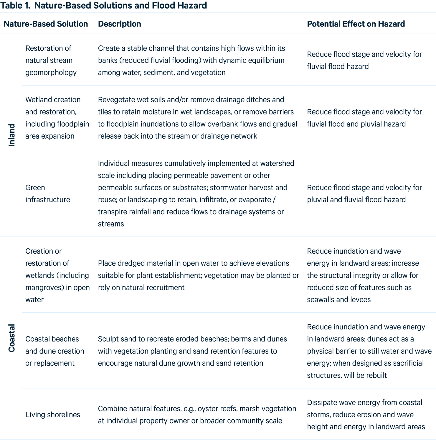
Table 1 elaborates on current modeling capability emphasizing the importance of representing site-specific conditions when predicting the hazard reduction achieved by NBS.
Within watersheds, the role of NBS can be predicted using widely accepted engineering modeling tools such as HEC-RAS and HEC-HMS. As one example, modeling of the 267 mi2 Cypress Creek watershed in Texas was used to predict how the location and size of wetlands within the watershed substantially reduced flood extent, flood depth, and flood duration for a 100-year 72-hour design rainfall event (Tang et al., 2020). Using site specific information on the watershed (e.g., a 3m digital elevation model), the relationship between downstream flood stage and wetland area was predicted and, for one illustrative location in the watershed, conversion of about 6% of watershed land cover to wetlands reduced downstream flooding to negligible levels.
BeachFX is a model that predicts the costs of shore protection alternatives with risk and uncertainty over multiple project life cycles. https://toolkit.climate.gov/tool/beach-fx (Accessed June 15, 2022) In the Coastal Texas Study analysis for South Padre Island, TX, the Corps of Engineers applied BeachFX to predict changes in the form and height of beaches and dunes and expected flood damages caused by coastal storm events. The modeling showed that revetments, seawalls, rock groins, or offshore breakwaters would disrupt longshore and cross-shore sediment transport processes. Further, the effects of beach nourishment and dune measures alone on expected damages were evaluated; a 12.5-foot dune plus 100-foot-wide berm were shown to provide coastal storm hazard reduction with damages-avoided benefits exceeding the life cycle project cost.
Modeling studies of coastal wetland systems and their effects on storm surge can utilize available models of coastal hydrodynamics and waves such as ADCIRC and SWAN (Rezaie et al., 2020) and Delft3d (Keisel et al., 2021). Modeling as well as field observations (e.g., Glass et al., 2018) report that reductions in still water stage do occur, although the effect varies with the extent and type of wetland as well as location, local elevation and geomorphologic features, such as width, channel form and edge configuration, and may be limited to low intensity storms.
The ability to change and adapt over time is often considered an advantage of some NBS. For example, salt marshes and oyster reefs can build vertically to keep pace with sea level rise (if conditions are right) in a way that a seawall cannot without major overhaul and investment. But that adaptation is difficult to predict and is itself dependent on many factors, for example, sediment supply for coastal marshes (Reed et al., 2018). Pests can cause dramatic change, such predation on oysters at high salinities (Pusack et al., 2019). While modeling and experimentation can predict NBS effects on flood hazard, ecological stresses cannot be anticipated or planned for, and some may be irreversible. Further, the impact of the flood hazard itself on the NBS can be varied and difficult to predict with certainty due to the ways in which flood stress can interact with ecological systems. For example, numerical models are available which can track changes in beach and dune morphology during storm events, but these changes are dependent on the specific characteristics of water levels and waves (Van Verseveld et al., 2015).
Predictions of the effect of increased coastal wetlands area (or preventing their loss), as well as for any other NBS, can be made using well established analytical tools and the predicted effect can be location specific. Model predictions will be accompanied by uncertainty; some uncertainty is due to natural variability and some is a result of knowledge gaps. Model uncertainty may be less for inland flooding than at the coast, as the existing topography and drainage network control flow direction – although the effect of antecedent conditions, such as soil moisture, seasonality in land cover, and infiltration potential – still present challenges. Some aspects of natural variability can be accounted for using probabilistic methods, such as those developed for considering coastal storm wave height and velocity hazards developed by the Corps following Hurricane Katrina. Such techniques can also be used to consider the effects of climate change, e.g., non-stationarity in precipitation and runoff, or increased storm intensity.
Meanwhile, research is rapidly advancing the ability of models to predict NBS effects on hazards. For example, while the specific characteristics of the NBS that contribute to wave attenuation (such as vegetation morphology and flexibility), are reasonably well understood, how the effects of individual plants scales over space in a wetland or forest fringe requires more detailed analysis. Laboratory flume studies have shown that 40m of real flexible coastal marsh vegetation can be effective in dissipating storm waves in water depths typically found during storm conditions (Möller et al., 2014). Recent wave tank studies with 40m of willows planted at the base of levees found that the trees reduce wave heights and wave run-up on levees even with wave heights up to 2.5m, allowing for reduced levee crest elevation (van Wesenbeeck et al., 2021).
In general, models for predicting NBS storm and flood hazard reduction for a specific area are well developed, but the accuracy of the site-specific prediction will require including site-specific conditions in the analysis. Knowledge of site-specific circumstances often is readily available for a community where the NBS will be implemented, enabling prediction of NBS benefits.
3. NBS, Federal Programs, and NFIP Rating Practices
Insurance premiums are a set rate for a certain amount of coverage purchased, intended to reflect the likelihood of different claims at a property during the term of an insurance contract. The charged premium is calculated based on the chosen coverage (deductible and maximum payment), addition of fees and surcharges, and applying premium discounts for actions that can reduce a property’s likelihood or size of expected claims. For example, homeowners insurance premiums might be reduced if the home has a fire alarm or the community built a new fire station in the neighborhood.
The NFIP describes RR2.0 as relying on state-of-the-art rating practices to set an insurance premium that reflects property specific expected flood claims. This commitment to reflecting property-specific claims should be mirrored by an equal commitment to charging a lower flood insurance premium when NBS investments reduce expected claims. However, as explained below, RR2.0 does not recognize the reduced flood claims from community NBS investments. A process for basing premiums on flood risk at the property while offering premiums savings for NBS investments also is described in this section.
3.1. RR2.0, NBS, and the Charged Premium: Current Practice
NFIP actuaries deployed state-of-the-art insurance catastrophe models, https://content.naic.org/cipr-topics/catastrophe-models-property (accessed June 15, 2022) best available landscape and watershed data from multiple sources, and NFIP claims data to create the Risk Rating Engine (RRE) for determining premiums charged under RR2.0. https://www.fema.gov/flood-insurance/risk-rating (accessed June 15, 2022) This RRE provides consumers with readily understood determinants of their premium and allows agents to quote an NFIP premium using these same rating factors when https://www.dhs.gov/sites/default/files/publications/privacy-piaappendix-fema-050-nfippivot-may2020.pdf (accessed June 15, 2022) the applicant for an NFIP policy provides their address, building descriptors, and chosen coverage and the RRE computes a 1st floor elevation for the property. Each property is in one of 115,862 “rating territories” defined by a HUC12 watershed boundary, https://databasin.org/datasets/f57141fecb9849bfa7ccd6ad6634c118/#:~:text=Description%3A,all%20land%20and%20surface%20areas. (accessed June 15, 2022) or in one of 14,866 territories defined as a levee protected area as represented in the National Levee Data Base (NLD). https://levees.sec.usace.army.mil/#/ (accessed June 15, 2022) Within a non-leveed territory, barrier island locations are separated from other coastal locations. For areas that are not levee protected or on a barrier island, a territory base rate reflects the modeled effects of geographic location on hazard and claims and includes an added charge for concentration risk. The RRE assigns the base rate to the property and then applies default “geographic risk-indicator” factors to adjust the base rate for the specific property. The property-specific geographic risk-indicator factors are (1) distance to the type of water body and (2) 1st floor elevation relative to the elevation of a type of water body (river, Great Lake coast and ocean). The policy applicant should understand that coastal storm hazards (still water stage, velocity, and wave height) diminish with distance. Distance is measured using Geographic Information Systems (GIS) representations of Great Lakes and ocean shoreline, and flow lines of rivers. The edge of the ocean was defined in a NOAA shoreline data base. https://www.ngs.noaa.gov/RSD/shoredata/NGS_Shoreline_Products.htm (accessed June 15, 2022) The characteristics of the land (or water) across that distance is not considered. Except possibly for increased beach width as an NBS, An NBS that adds width to a beach increases the distance to the coast. In principle, this increased distance could be reflected in the GIS layer that is used to define the shoreline. However, for the NBS to be reflected, the GIS data need to be updated and the size of the beach project needs to be of sufficient size to be captured by remote sensing and included in the GIS data base. no NBS can increase the GIS representation of the distance to the water body. Engineering models might make predictions of the localized effect on hazards, but these effects will not be reflected in the distance rating variable. To illustrate, coastal wetlands and living shoreline investments (see Table 1) would not change the distance rating factor, but these NBS might affect stage, velocity, or wave hazards at the property. In the inland setting, no NBS in Table 1 can affect distance to a river, so the distance variable as a risk indicator is unaffected by the NBS investment.
As stated above, 1st floor elevation relative to these same water bodies is a risk rating factor. Prior to RR2.0, rating was based on 1st floor elevation relative to the stage of the 100-year flood in the immediate area (a flood zone) where the property was located; this was called the base flood elevation (BFE). RR2.0 replaced the BFE reference with a GIS representation of elevation of the Great Lakes or ocean, or of a nearby river stage. Measured river stage within a HUC might be affected by NBS. However, for the NBS effect on stage to be reflected, a hydrologic and hydraulic evaluation would need to be completed and the results reflected in the elevation of the reported river stage at the HUC level used as the refence for the rating factor. Measured river stage within a HUC might be affected by NBS. However, for the NBS effect on stage to be reflected, a hydrologic and hydraulic evaluation would need to be completed and the results reflected in the elevation of the reported river stage at the HUC level used as the refence for the rating factor. For example, the Great Lakes elevation is represented as the long-term average water level for each lake. Except possibly for an NBS that affects river stage, NBS cannot affect the measures of elevation at these larger water bodies. Engineering models might predict reductions in localized flood stage for a group of properties, but these localized effects will not be reflected in the river elevation metric used for rating. If a community invested in extensive green infrastructure and wetlands creation (Table 1), engineering models might predict hazard reduction from NBS that reduce the hazard from intense rainfall flooding, but no rating metric reflects that hazard reduction.
3.2. A Proposed Approach to Crediting for Premium Savings
The process used by RR2.0 to quote premiums in levee protected areas and offer premium savings for levee improvements provides an analogy for how the NFIP can recognize investments in community NBS and in turn offer premium reductions (FEMA 2022). FEMA (2022) Levees in Risk Rating 2.0. In levee protected areas, RR2.0 considers levee crest elevation and a “levee quality score” for crediting the hazard reduction from a levee and then setting premiums. The levee quality score is based on a levee fragility curve that uses the structural condition of the levee in combination with the predicted likelihood of different flood stages against the levee to represent the possibility of a levee breach prior to overtopping from the toe to the levee crest. Premiums in a levee protected are based on zero damages (claims) if the levee is not overtopped or does not breach; damages (claims) if the levee is overtopped or breached follow the rating factors for a non-levee protected area. In concept, a community could make an investment to increase the levee crest or improve the structural conditions at the levee to improve the levee quality score. These changes would be reported in the national levee data base and premiums would be reduced for those properties located in the levee protected area. Underlying this process are models accepted by the NFIP for creating a levee quality score. The NFIP could in a similar way accept model predictions of NBS effectiveness to credit hazard reduction and offer premium savings from a community investment in NBS.
The community would formulate an NBS investment for a specific location. Then, modeling tools such as those discussed in the previous section would be used to predict the site-specific reduced hazard. The catastrophe models will be rerun on some frequency to update the base rate. At that time any new NBS on the landscape might be detected, represented in the GIS databases used for the modeling and might lower the territory base rate. However, from the available documentation of the RR2.0 underlying modeling it does not appear that the effectiveness of an NBS would be captured as base rates are being updated. The use of advanced technical models is already an expectation of applicants for FEMA grants for NBS and the expected technical sophistication of the modeling is more demanding as the amount of funds requested increases. A recent TNC report on FEMA BRIC and HMGP grant programs notes: “Engineering models will typically be required for large-scale, complex engineering projects or projects located in heavily urbanized areas and should be scoped to include NBS. The complexity of the model needed will depend on the nature-based project type and the site conditions. There may be existing models and studies that can be used in place of a new model. Any study or model used to justify the project should be certified by a licensed professional.” FEMA (2022) Levees in Risk Rating 2.0. To encourage a community to be willing to pay for the modeling required to predict hazard reduction, and then to invest in the NBS itself, the NFIP needs to clearly describe the technical requirements for earning credit toward premium savings for NBS investments.
The NFIP would provide guidance to communities describing the modeling requirements and the criteria for awarding premium savings from NBS implementation. Several considerations could guide the NFIP in developing procedures for premium discounts for NBS. The NFIP might deny premium discounts to any NBS that is not eligible for HMA grant funding. For example, some FEMA grant programs will not fund beach nourishment and re-nourishment activities. Model prediction uncertainty may limit the premium savings offered. For example, modeling of rainfall intensity and magnitude from coastal storms is often accompanied by a large band of uncertainty, which in turn creates uncertainty about the hazard reduction from inland NBS. The effectiveness in reducing hazards for different storm magnitudes may be a consideration when awarding premium savings. For example, if the NBS reduces the hazard from smaller storms but not larger storms, the effect on expected damages that is the basis for setting premiums may be small. Different NBS may require different maintenance commitments; those that require higher maintenance, as is the case with the Corps Levee Safety Program, may need to be periodically inspected and recertified by the community.
3.3. Political support and a revenue source for NBS
NBS can offer a variety of benefits to a community, so a community’s decision on whether to invest in NBS may be based on factors aside from storm and flood hazard reduction or premium savings. That said, storm and flood risk reduction can be predicted and assigned to specific property owners, some of whom would be willing and able to pay a share of the costs for the NBS. The NFIP could encourage community investments in NBS by accepting the model predicted hazard reductions and then offering premium savings to existing and potential NFIP policy holders who would benefit from the community NBS investment.
Capturing a share of premium savings for funding NBS has been proposed as a conceptually feasible idea (Reguero et al., 2020). However, as has been discussed in this paper, moving from a general concept to the offer of premium savings in the specific NFIP context is not a straightforward process. And even if NFIP premium savings from the NBS were awarded, the community still must decide if they want to collect payment from the benefiting property owners as revenue source for NBS funding, and how to structure the payment process, especially when premium savings alone may not cover a significant share of the NBS cost. A practical option would be to identify the property owners who benefit from the NBS and who have an NFIP policy, or might find the policy affordable with NBS in place. Then the community would calculate the realized premium savings and charge a fee or tax similar to the practice of levee or beach improvement districts that are common throughout the nation, and that have a long history. Resources Radio (2020). Shifting Sands: Using Taxes to Build the Best Beaches, with Megan Mullin (podcast). January 14. A recent report suggests that this approach might best be applied in the context of a private offering of community-based insurance. See: Munich Re and the Nature Conservancy (2021). Nature’s remedy: Improving flood resilience through community insurance and nature-based mitigation.
4. Conclusions
The NFIP, housed in FEMA, designed RR2.0 to charge premiums that better reflect property specific flood risk. In addition, FEMA and other federal agencies are increasingly advocating for NBS to reduce storm and flood hazard. However, RR2.0 rating practices cannot accept site-specific predictions of hazard reduction from an NBS investment to offer premium savings for benefitting properties. A community might be motivated to invest in the modeling, and then in the NBS itself, if the NFIP developed a protocol for translating the predicted hazard reduction from the NBS for benefiting properties into premium savings. Also, a community might choose to capture some of the savings to fund the implementation of the NBS.
FEMA Administrator, Deanne Criswell, could well have been talking about NBS when she told the International Association of Emergency Managers and the National Preparedness Leadership Initiative at the October 2021 meeting, “We have such an opportunity right now to do more system-based, communitywide projects that have an impact on a whole neighborhood and move away as much as we can from an incremental approach to hazard mitigation…,” although Criswell did not say how FEMA would encourage states and municipalities to undertake communitywide mitigation projects (Frank, 2021). This paper argues that such encouragement could come from NFIP offering premium reductions from NBS that serve the larger community.
To view the whole issue brief with references, click "download" below.
Authors

Denise Reed
Professor Gratis, University of New Orleans


